


Long before railways or motorways, sacred journeys produced the ancient world’s most ambitious civil engineering. But the roads did not follow the faith. They followed the treasury.
Somewhere on the northern rim of the Nafud, in the decades either side of the year 800, a gang of labourers was dragging cut stone across sand.
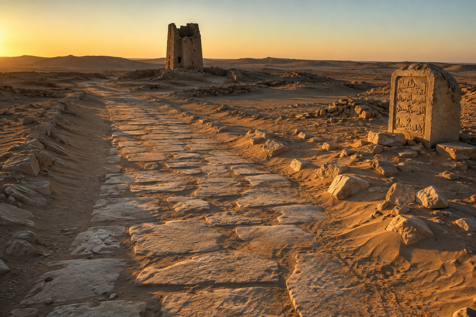
Modern survey has traced a little of what they built. Along a stretch of roughly forty kilometres between two water stations with the unglamorous names of Buraykat al-Ashshar and Birkat al-‘Ara’ish, a paved strip two to four metres wide still lies across the dune field, slab set beside slab, pressed flat into a surface that holds nothing flat for long. Feeding and watering the work gangs across such ground was an operation of some complexity in itself. The paving had a single purpose: to stop soft sand from swallowing a walking foot at every step.
No merchant had asked for it. Caravan commerce had crossed Arabia for centuries by doing the sensible thing and going round the deep sand, or by pricing the risk and moving at the pace of camels rather than pedestrians. The stone was laid because once a year, on a date fixed by a lunar calendar with which no engineer could negotiate, a mass of people had to cross that ground in one direction, at one time, and arrive by a deadline. Many of them were on foot. Many were old. Almost none were carrying anything to sell.
That paved strip belongs to the Darb Zubaydah, the pilgrimage road running roughly 1,400 kilometres from Kufa in present-day Iraq to Mecca. It is one node in a much larger and much less familiar story: that for most of recorded history, the heaviest and most sophisticated civil engineering undertaken by states was built not for armies or for trade but for the periodic movement of worshippers.

There is a comfortable way of telling that story, and it is not quite right. In the comfortable version, faith produces roads. Pilgrims walk; paths form; traffic thickens; investment follows devotion the way a riverbed follows water. Belief is the cause and infrastructure is the sediment.

The evidence points somewhere closer to the reverse. The great pilgrimage corridors were financed, engineered, maintained and abandoned according to the calculations of dynasties and treasuries rather than the intensity of belief. They appeared where a ruler had a reason to be seen paying for them. They decayed when that reason lapsed — while the pilgrimage itself carried on regardless, rerouted through whichever territory happened to have a sovereign willing to fund the wells. The road did not follow the faith. It followed the state that wanted credit for the faith.
Read that way, the pilgrimage network stops being a picturesque footnote to religious history and becomes something more interesting: the longest-running experiment in public infrastructure that human societies have ever conducted, and one whose institutional inventions — the hostel, the permit, the endowment, the quarantine, the managed crowd — have outlasted almost every road surface they were built to serve.
DEFINITIONS · A ROAD IS THE LEAST OF IT
Infrastructure Before Infrastructure
Infrastructure is usually pictured as hardware: the thing you can photograph. Pilgrimage systems certainly generated hardware in quantity — paved causeways, arched bridges, harbours, cisterns, dams, wells, milestones, watchtowers, hostels, hospitals, ferry landings, mountain hospices. But hardware was always the smaller half.
The larger half was procedural. To move an enormous number of unfamiliar, poorly equipped travellers across a landscape and return most of them alive, a state needed things that leave no ruins: route surveys and written itineraries; standard distances between halts, calibrated to how far a loaded animal or an exhausted human could actually go in a day; letters of introduction and travel permits; policing arrangements and negotiated protection payments to whoever controlled the intervening terrain; currency exchange and credit; provisioning contracts; rules for the disposal of the property of those who died en route; and, increasingly, sanitary controls when it became obvious that concentrating strangers concentrated disease.
Consider how strange pilgrimage traffic is as a customer for any of this. Its demand is violently seasonal, compressed into weeks. It is largely unidirectional: everybody goes one way, then everybody comes back, so half the capacity sits idle at any moment. It carries little freight, which means it generates limited transport revenue on its own account. It runs to an immovable ritual deadline, which removes the traveller’s ability to wait out bad weather or a broken bridge. And its participants are disproportionately old, poor, unwell or unfamiliar with the terrain — precisely the population least able to improvise when something fails.
By any ordinary logic of investment, this is a demand profile that argues against building. Every engineering economist since has been taught the opposite rule: build where flow is continuous, bidirectional and commercial. Yet across at least fifteen centuries and every major religious tradition with a fixed destination, states built anyway, and built beyond what the traffic could ever repay.
“Every engineering economist since has been taught the opposite rule: build where flow is continuous, bidirectional and commercial. States built anyway.”
Which tells us that the demand being served was not, in the first instance, the pilgrims’. It was the ruler’s.
BURDIGALA → HIEROSOLYMA · 333 CE
The Inheritance of Rome
The earliest surviving Christian travel account is not a devotional text. It is a logistics document.
In 333 an anonymous traveller left Bordeaux for Jerusalem and wrote down the journey as a road engineer might: a sequence of civitates, mansiones and mutationes — cities, overnight halts and posting stations for changing animals — with the distance in Roman miles between each. The pilgrim of Bordeaux, as the writer is now known, appears to have been using the cursus publicus, the imperial courier and transport system, whose facilities were not built for pilgrims at all. Only when the account reaches the Holy Land does the register shift and the biblical sites begin to be described.
That document captures the founding condition of Christian pilgrimage in Europe: it did not build a network, it inherited one. Constantine’s basilica programme supplied destinations; the Roman road system, already several centuries old and engineered for legions and tax collectors, supplied the means of reaching them. For the first few generations, Christian long-distance travel was a new use for existing plant.
The building came later, and it came in a recognisably medieval form: local, endowed, and driven by patrons who wanted their names on it. By 990, when Sigeric, Archbishop of Canterbury, returned from Rome after receiving the pallium, he could list his journey as seventy-nine stages — submansiones — along a corridor already known by the ninth century as the Via Francigena. That road-book is now the basis of a signposted long-distance route certified by the Council of Europe in 1994, which is itself a fair measure of how thoroughly a logistics memorandum can outlive the man who wrote it.
The most revealing figures on the northern Spanish routes are not the saints who were venerated but the ones who did the earthworks. Domingo García — known to history as Santo Domingo de la Calzada, Dominic of the Causeway — spent the middle decades of the eleventh century clearing forest, draining marsh, cutting a paved road to replace a deteriorating Roman alignment, throwing first a timber and then a stone bridge across the river Oja, and founding a hospital beside it. He died in 1109. Spanish civil engineers now claim him as their patron. His collaborator Juan de Ortega carried on the same programme of bridges, roads and hospices further west. Sanctity, in the eleventh-century Rioja, was a public works portfolio.
“Sanctity, in the eleventh-century Rioja, was a public works portfolio.”
The settlement that formed around Domingo’s hospital became a town, then a cathedral city; his hospital was still functioning in the nineteenth century. UNESCO’s own description of the Santiago routes, inscribed in 1993 and extended since, lists the built heritage that pilgrimage produced with the flatness of an asset register: cathedrals, churches, hospitals, hostels, bridges.
And when demand outran capacity, the response was the response of any transport authority. During the first Jubilee of 1300, so many people were crossing the single narrow bridge between central Rome and St Peter’s that traffic was divided into two lanes, one for each direction — a detail preserved, of all places, in Dante’s Inferno, where the poet uses the arrangement to describe the circulation of the damned. It is among the earliest recorded instances of deliberate pedestrian flow separation anywhere. It was also insufficient. In December 1450, during a later Jubilee, a panic on the same bridge collapsed the balustrades and chroniclers record that roughly two hundred pilgrims drowned in the Tiber. Within a generation the papacy had built an additional bridge across the river. Ponte Sisto is, in the plainest sense, a capacity upgrade paid for by a crowd disaster.
KUFA → MAKKAH · c. 1,400 KM
The Hajj Network and the Economics of Water
If Christian Europe adapted an inherited network, the early Islamic world did something harder. It engineered a corridor from scratch across terrain that offered almost nothing.
The obligation of the hajj creates a problem with no equivalent elsewhere: a fixed destination, a fixed date, and a catchment stretching from the Atlantic to Central Asia. The Abbasid answer, developed most intensively between roughly 750 and 850, was the road that later took the name of Zubaydah bint Ja‘far, wife of the caliph Harun al-Rashid, whose endowments funded so many of its stations that her name attached itself to the whole system.
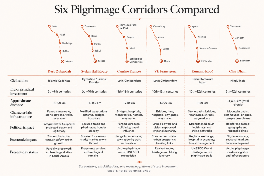
The engineering vocabulary is worth stating precisely, because it is the vocabulary of a planned network rather than an accumulated track. Twenty-seven principal stations were laid out between Kufa and Mecca at intervals matched to the daily range of donkeys, horses and camels, measured in a unit called the barid — a word that also means the postal service, which tells you what else the road was for. A further twenty-seven intermediate stations were added later specifically to accommodate the growing number of pilgrims travelling on foot. Along the route stood wells, dams, open reservoirs known as birak, rest houses, forts, milestones and road markers, and — at Umm al-Qurun, near the northern end — a manara, a tower built to guide travellers moving at night. In the Nafud, where sand defeats everything, they paved.
“The stations were spaced in units of the barid — a word that also means the postal service. That tells you what else the road was for.”
None of this was unprecedented in intent. Wells had been dug along the Basra and Kufa approaches under the earliest caliphs, and the oasis of Fayd, roughly halfway along, had been developed as a strategic node well before the Abbasids. What changed under Baghdad was scale, standardisation and central financing — the difference between a road that exists and a road that is administered.
The Iraqi corridor was never the only one. The Syrian route from Damascus to Medina, at about 1,307 kilometres, is the oldest used by pilgrim caravans, and it acquired its own dense apparatus of cisterns and small forts under the Mamluks and then the Ottomans. An Egyptian route ran from Cairo. Each of these corridors carried commerce as well as worship, and the two were not easily separated: Mamluk sultans drew substantial revenue from the markets that clustered along the Syrian road, and Sultan Barsbay in the fifteenth century is recorded attempting to stop merchants travelling with the Syrian caravan altogether — an intervention that only makes sense if the pilgrimage convoy had become, in effect, a scheduled freight service the state wished to control.
This is the crucial point. The hajj road was simultaneously a devotional artery, a trunk route, a postal spine, an intelligence channel and a taxable asset. No one at the time would have thought those functions separable. It is only modern habit that files them under different ministries.
CHANG’AN → NĀLANDĀ · THE MONASTERY AS TERMINAL
Buddhist Networks and the Invention of the Waystation
Across Asia the pattern differs in one decisive respect: the infrastructure was not primarily a road. It was a chain of institutions.
As Buddhism spread along the trans-Asian trade corridors from around the first century BCE, monastic communities established themselves in the oasis towns that structured those corridors. The vihāra became something no purely commercial settlement had produced: a standing, non-profit facility offering shelter, food, medical care and information to any traveller who arrived, financed by donation rather than by charging the user. Merchants used them. Envoys used them. Pilgrims used them. In effect, the monastic network supplied the service layer that a modern transport corridor gets from motorway services, clinics and hotels, and it supplied it centuries before any state in the region attempted the same.
The documentary layer is equally striking. A manuscript recovered from the Silk Road archives is a letter of introduction for a pilgrim monk travelling from China, addressed to monastic leaders and officials in the next town, asking that they assist him on his way; written in Tibetan, it dates to the period when that language served as a regional lingua franca. Xuanzang, travelling to India in the seventh century, was furnished with comparable letters by the king of Karashahr for the oasis states ahead of him. These are not devotional objects. They are travel documents — an interoperable identity and referral system operating across a dozen polities that shared no common sovereign.
The most valuable surviving account of how the whole apparatus actually functioned comes from Ennin, a Japanese monk who travelled in Tang China between 838 and 847 and kept a diary of relentless practicality: prices, provisions, the conduct of prefectural clerks, and above all the permits he repeatedly failed to obtain. It is a portrait of pilgrimage as a matter of paperwork.
Ennin also recorded, day by day, what happened when the state changed its mind. In 845 the Tang court moved against Buddhist institutions across the empire. Ennin describes the arrival of an imperial order directing that bronze and iron images be smashed, weighed and delivered to the Salt and Iron Bureau; hundreds of thousands of monks and nuns were returned to lay life and monastic landholdings were confiscated. The suppression was, among other things, a fiscal operation — the direct conversion of sacred infrastructure into state metal and taxable land.
“Nothing about Buddhist belief in China changed in 845. What changed was the position of a treasury.”
Nothing about Buddhist belief in China changed in 845. What changed was the position of a treasury. Within a single year, the most extensive network of free hospitality in Eurasia was reduced by administrative decree. If one wanted a controlled experiment to test whether devotion or fiscal policy determines the fate of pilgrimage infrastructure, it would be difficult to design a cleaner one.
PRAYĀGA · A CITY BUILT FOR FORTY-FIVE DAYS
Rivers, Ghats and the Temporary Metropolis
The Indian pilgrimage systems pose a different engineering problem again. The difficulty is rarely distance. It is crossing, and above all concentration.
Sacred geography in South Asia is organised around water — confluences, fords, riverbanks, coastal points — which means the physical works that pilgrimage demanded were characteristically ghats, embankments, ferry landings, tanks and bridges rather than long-haul highways. And because auspicious moments are astronomically determined, the resulting flows are not merely seasonal but instantaneous: enormous numbers of people converging on a riverbank within hours of one another.
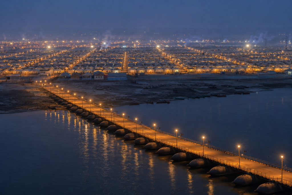
The most complete modern expression of this is the Kumbh Mela, and the 2025 gathering at Prayagraj shows the scale of what such an event now requires. The site covered some 4,000 hectares. Thirty pontoon bridges were assembled from more than three thousand individual pontoons; scores of city roads were rebuilt; the state government created a dedicated temporary administrative district for the duration of the forty-five-day festival, with its own sanitation, policing, power and medical apparatus. Published budget figures for the event run to the order of seventy billion rupees.
Attendance claims for the 2025 Mela — widely reported in the range of several hundred million — come from state authorities and are not independently audited; they should be read as official estimates rather than measurements, and specialists differ considerably on how they were derived. What is not in dispute is that the logistical demand exceeded what was provided. A fatal crush occurred on one of the principal bathing days, and subsequent analysis identified extended walking distances, congestion and last-mile connectivity as unresolved weaknesses. Crowd management remains, as it was on the Ponte Sant’Angelo in 1450, the hardest unsolved problem in pilgrimage engineering.
“Crowd management remains, as it was on the Ponte Sant’Angelo in 1450, the hardest unsolved problem in pilgrimage engineering.”
The permanent counterpart is the Char Dham road programme in Uttarakhand: 889 kilometres of Himalayan national highway upgraded to all-weather two-lane standard across fifty-three separate works, connecting the four principal shrines of Yamunotri, Gangotri, Kedarnath and Badrinath at a sanctioned cost in the order of a hundred and twenty billion rupees. Its stated justification is pilgrim safety. Its second, openly acknowledged function is military supply to forward positions on the Indo-Chinese frontier. The project has been contested in the courts on environmental grounds for most of its life.
SIENA · THE HOSPITAL THAT OUTLIVED THE ROAD
What the Road Built
The commercial consequences of pilgrimage are often described in general terms — markets grew, towns prospered. The specific mechanism is more interesting, and it is not the road. It is the hostel.
Because pilgrimage hospitality was given rather than sold, it had to be endowed. Endowment meant land. Land meant a corporation with a balance sheet, and pilgrim institutions became, in several places, the largest economic actors in their region.
Santa Maria della Scala in Siena is the clearest case. Documented from 1090 and probably older, it sat on the Via Francigena and existed to shelter and treat pilgrims, along with the poor and abandoned children. Sienese families endowed it; by the thirteenth and fourteenth centuries it had organised its holdings into large agricultural estates, the grance, spread across the Val d’Orcia, the Val d’Arbia, the Maremma and beyond. Those holdings have been described as the largest single concentration of land in the Sienese state. The hospital was still admitting patients in the twentieth century; it closed in 1995 and reopened as a museum. It functioned for something close to nine hundred years — far longer than the road that produced it functioned as a road.
“The pavement decayed. What survived was the software: the endowed hostel, the charitable trust, the standardised day-stage, the guidebook.”
That is the general shape. Around the demand for lodging clustered everything else: money-changers, because pilgrims arrived with foreign coin; brokers and guides; notaries, because travellers wrote wills before departure; carriers and animal hire; and a substantial manufacturing trade in badges, tokens and devotional souvenirs, the medieval world’s most reliable proof-of-visit industry. Markets grew where caravans halted, and stayed after the caravans changed route. Fixed halting distances — a day’s walk apart — seeded settlements at intervals that no purely agricultural logic would have chosen, and many of those intervals are still visible in the spacing of towns along the Camino Francés and the Via Francigena today.
It is worth noticing which layer proved durable. The pavement decayed. The bridges were rebuilt or lost. What survived, sometimes for the better part of a millennium, was the institutional software: the endowed hostel, the charitable trust, the standardised day-stage, the hospital, the guidebook. When the Codex Calixtinus in the twelfth century told pilgrims which rivers on the Spanish route were safe to drink from, it was performing an act of infrastructure as surely as any bridge builder — and its information could be copied at a cost the bridge could not match.
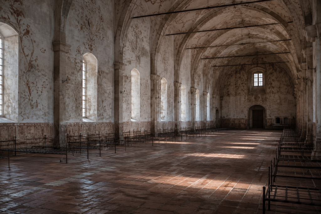
LEGITIMACY, PURCHASED BY THE MILE
Sacred Geography as Political Geography
Why, then, did rulers pay?
Because a pilgrimage road delivers something a military road cannot: visible, uncontroversial, continuously renewed legitimacy. A ruler who digs wells on the route to a holy city is not merely providing a service. He is publishing a claim — that this territory is his to administer, that his authority is exercised for the benefit of the faithful, and that anyone travelling the road is travelling through his protection.
The claim is also administratively productive. Station spacing measured in units of the postal service meant that the pilgrimage road doubled as a communications spine and an intelligence channel across an empire that stretched from North Africa towards the borders of China. Forts built to protect pilgrims garrisoned regions no revenue officer could otherwise reach. Charters and endowments along the route created a legal presence in landscapes that were, in every other respect, ungoverned. In eleventh-century Castile, bridges, hospitals and inns were commissioned along the Santiago road on royal instruction during precisely the decades when the kingdom was pushing its frontier southwards. Infrastructure and territorial consolidation were one policy.
“A ruler who digs wells on the road to a holy city is publishing a claim: that this territory is his to administer.”
The most explicit case is also the most recent. In 1900 Sultan Abdülhamid II appealed to Muslims worldwide to fund a railway from Damascus to the holy cities. Built by public subscription, with German engineering advice and without foreign state finance, the line reached Medina in 1908 across roughly 1,300 kilometres. It cut the journey from Damascus from around forty days to a matter of days. It also allowed Ottoman troops and materiel to move into Arabia at unprecedented speed, projected imperial authority against European encroachment, and underwrote the sultan’s claim to the caliphate at a moment when the empire was losing territory on every other front. Contemporaries understood all of this simultaneously. It was a pilgrimage service, a strategic railway and a legitimacy instrument, and nobody found the combination remarkable.
The pattern has not lapsed. The Char Dham highway is a pilgrim road and a border supply line. The logic that laid slabs across the Nafud is the logic that tunnels through the Garhwal Himalaya.
THE TEST CASE
When the Road Dies and the Faith Does Not
If pilgrimage infrastructure were a function of devotion, its decline would track a decline in devotion. It does not. It tracks the solvency and attention of states, and the Darb Zubaydah is the demonstration.
After the great period of ninth-century investment, caliphal maintenance became intermittent. The consequences appear in the chronicles as a sequence of failures with a common signature. In 843 pilgrims suffered in extreme heat while water was sold along the road at extortionate prices and the caliph did not intervene. In 967 many died of thirst on the way. In 1004 pilgrims were struck by wind and thirst again. These are not accounts of a road that people had stopped using. They are accounts of a road that people were still using after the institution responsible for its wells had stopped functioning.
By the tenth century the breakdown of communication between Iraq and Mecca was materially impeding Iraqi and Persian pilgrims. After the Mongol capture of Baghdad in 1258 the Iraqi caravan was suspended for a decade, and most of the stations along the route were lost.
The hajj, of course, continued without interruption. What changed was its plumbing. Traffic migrated to the Syrian route out of Damascus and the Egyptian route out of Cairo, where Mamluk and later Ottoman authorities were investing in exactly the apparatus the Abbasids had abandoned: forts, cisterns, subsidised escorts, and the annual imperial convoy that carried stipends and gifts to the holy cities. Pilgrimage did not decline. It changed sovereign.
“Pilgrimage did not decline. It changed sovereign.”
The same test can be applied elsewhere and returns the same answer. Tang China’s monastic hospitality network collapsed in 845 by decree rather than by disbelief. In sixteenth-century northern Europe the dissolution of shrines removed, at a stroke, the demand base that had sustained whole classes of hostelry and roadside trade — an economic shock delivered by legislation. Epidemic disease repeatedly closed routes that no theological argument had touched, and produced in response one of pilgrimage’s more consequential institutional exports: the quarantine station.
There is a final, very modern illustration. When Ottoman planners proposed extending the Hejaz line beyond Medina to Mecca, tribes along the route — whose camels, escorts and tolls constituted their income from the pilgrimage — resisted. The sultan declared that the railway would go no further. An incumbent transport industry had successfully blocked its replacement, a century before anyone had a phrase for it. What the tribes could not block, the First World War completed: the line was wrecked in the fighting and much of it has never carried a scheduled passenger since.
THE SECOND LIFE
From Sacred Roads to Heritage Corridors
In the last three decades these corridors have acquired a second economic function, and it has been produced by designation rather than by devotion.
The Santiago routes were inscribed on the World Heritage List in 1993, with the French routes following in 1998 and later extensions adding roughly 1,500 kilometres of northern Spanish itineraries. The Via Francigena was certified as a Cultural Route by the Council of Europe in 1994. The sacred sites and pilgrimage routes of Japan’s Kii mountain range were inscribed in 2004; the wider property now attracts up to fifteen million visitors a year. Iraq and Saudi Arabia have jointly advanced the Darb Zubaydah for inscription as a transnational serial property, with archaeological survey work continuing on the Iraqi stations.
Designation functions, in practice, as regional development policy. A heritage listing converts a decayed corridor into a signposted product with a governing association, a waymarking standard, a certification scheme and a distributed hospitality economy along its length — which is, allowing for the change of vocabulary, exactly what the eleventh-century endowment of hostels and bridges achieved.
“A heritage listing converts a decayed corridor into a signposted product — which is, allowing for the change of vocabulary, exactly what the eleventh-century endowment of hostels achieved.”
The numbers are considerable. In 2000, just over 55,000 people collected the Compostela certificate on arrival in Santiago. In 2024 the figure was close to 500,000, and in 2025 it passed 530,000 for the first time — and that count captures only those who complete the formalities, so the true walking population is higher. Japan’s Shikoku circuit, some 1,200 kilometres around eighty-eight temples, sustains a comparable ecology of lodging and transport. Surveys of Camino walkers consistently show a mixture of religious, spiritual, cultural and personal motives rather than the disappearance of the first; secularisation here has diversified the traffic rather than ended it.
Meanwhile the older logic proceeds undiminished. The Haramain high-speed line runs 453 kilometres of electrified track between Mecca and Medina by way of Jeddah at speeds up to 300 kilometres an hour; for the 2026 hajj season the operator scheduled more than five thousand services offering upwards of 2.2 million seats, with a scheme to move pilgrims’ luggage separately from the departure airport. It is the Darb Zubaydah’s direct descendant: the same route, the same clientele, the same seasonal spike, the same state calculation about who gets credit for solving it.
RETURN · THE NAFUD
What the Desert Kept
The slabs are still in the Nafud.
They have been drifted over and uncovered again for twelve centuries, and they no longer lead anywhere in particular. The birak beside them hold sand rather than rainwater. The lighthouse at Umm al-Qurun still stands, some distance from its station, having been built to guide people who stopped coming a very long time ago. Archaeologists working the route photograph the pavement in sections and record its width, which varies between two and four metres depending on what the dunes were doing when the gangs came through.
It is tempting to read such remains as monuments to belief, and they are not quite that. Belief did not lay them. Belief created a recurring, non-negotiable, politically legible movement of people, and states then competed to be the ones who made that movement possible — because the wells and the forts and the paved miles bought them something that could not be purchased any other way. When the competition moved elsewhere, the wells were left to fill.
This is not a diminishment of the pilgrims. It is a fairer account of what they set in motion. Their journeys generated the earliest sustained demand for long-distance mobility of ordinary people, at a period when no other force in society required it, and in meeting that demand human societies invented and re-invented most of the components of a public transport system: the timetabled stage, the graded road, the roadside hospital, the traveller’s permit, the charitable trust, the crowd lane, the quarantine, the guidebook, the through-ticket.
Every one of those was worked out on a road to a shrine. And the last of them, the ones that travelled furthest, were never made of stone.